Posts in Category: 2011 Storm Chases
May 23rd 2011
On April 11, 2014
- 2011 Storm Chases
Where to begin?
We’ll Joplin had been virtually wiped off the map barely 18 hours prior, I was feeling the effects of sleep exhaustion between driving, forecasting, late nights and relatively early mornings.
Today by all accounts was going to be a good chase day with dryline driven storms and a warm front pushing north.
The shear environment was good, not perfect, but very good. The energy values were again off the chart!
With Joplin so fresh on my mind and most chasers retreating west for today’s Oklahoma storms I think another Joplin scenario was hanging over everyone’s heads as a possibility.
There were real concerns that today could be the day Oklahoma City was the target!
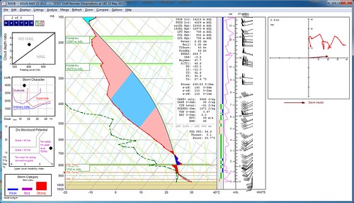
This was the midday sounding from KOUN which is the nearest station.
The real temperature and dew point at the time of the supercell were a few degrees higher but this sounding still gives a clear indication of the type of energy in the atmosphere.
The MVV (maximum vertical velocity) was 89 m/s or 320 km/h! Those are dangerous maximum updraft speeds, it was no wonder baseball sized hail was reported from this storm.
SB cape values were around 4000 j/kg. Such high capes on their own, are often enough for standard types of damage weather from downbursts, outflow winds and the like.
Sometimes the numbers, the real numbers from actual observed data in Tornado Alley are just ridiculous to look at. You have to shake your head and say "are these environmental conditions on the meso-analysis models really even possible?". Then you look at a midday sounding, drop your jaw and say "well I guess the weather models were actually on the conservative side".
You just can't argue with observed data, especially when everything points in the same direction and what seemed crazy in the morning is an actual observed data-set in the afternoon.
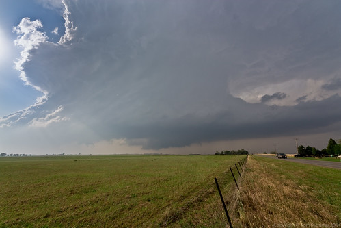
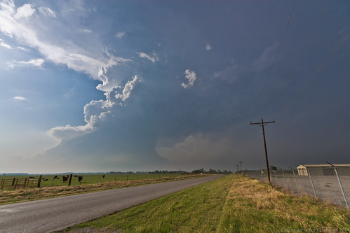
You just don't see structure like this ever, at least not on a regular basis.
This picture does not even do this storm justice, the winds alone made it amazing to watch. It was like watching really fast timelapse video, except it was all happening in real time!
The wall cloud visible in the center middle portion of the video was cranking but it never really did come together perfectly.
At the time, I thought for sure it was going to turn into a monster wall cloud, drop a huge stove pipe and morph into an HP monster storm.
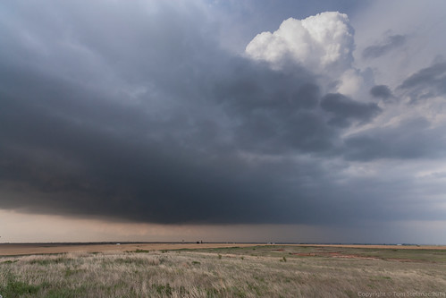
All good things have to come to an end, and unfortunately, outflow billowing south from storms that developed along the warm front to the north began to interact with this supercell negatively. The storm motion was also so slow that the dryline eventually sneaked up from the south and undercut it with a small bulge. The storms immense inflow winds probably helped to suck in the dryline!
The final nail in the coffin was the 500 mb wind which was blowing out of the west and venting the storm to the east, which was also it's unfortunately its general motion. So the storm was running over its own outflow which is always problematic!
Had the 500 mb flow been out of the south things would have likely been very different venting all the outflow to the north of the updraft and saving it from running over cooler air.
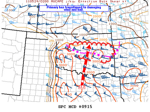
This MCD shows where the developing line of storm which turned into a nasty MCS ended up in the evening. This mess provided some isolated but elevated supercell on the eastern areas.
MESOSCALE DISCUSSION 0915
NWS STORM PREDICTION CENTER NORMAN OK
0922 PM CDT MON MAY 23 2011
AREAS AFFECTED...W-CNTRL THROUGH CNTRL AND ERN OK
CONCERNING...TORNADO WATCH 345...348...
VALID 240222Z - 240245Z
THE SEVERE WEATHER THREAT FOR TORNADO WATCH 345...348...CONTINUES.
PRIMARY THREATS APPEAR TO HAVE TRANSITIONED TO DAMAGING WIND AND
LARGE HAIL. WW 345 IS SCHEDULED TO EXPIRE AT 03Z. ONE OPTION IS TO
REPLACE BOTH 345 AND 348 BY A SINGLE SEVERE THUNDERSTORM WATCH PRIOR
TO 03Z.
STORMS SHOULD CONTINUE DEVELOPING WITHIN ZONE OF ISENTROPIC LIFT
NORTH OF CONVECTIVE OUTFLOW BOUNDARY SUPPORTED BY A SLY LLJ. STORMS
HAVE BEEN BACKBUILDING ALONG THE WRN PORTION OF THE BOUNDARY AND
HAVE MAINTAINED SUPERCELL STRUCTURES...WHILE STORMS IN ERN OK HAVE
BECOME FORWARD PROPAGATING. AN ISOLATED TORNADO CANNOT BE RULED
OUT...BUT CURRENT THINKING IS THAT STORMS WILL REMAIN AT LEAST
SLIGHTLY ELEVATED ON COOL SIDE OF THE BOUNDARY WITH THREAT FOR
MAINLY LARGE HAIL AND DAMAGING WIND.
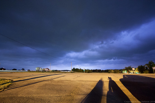
We ended our chase day just east of Oklahoma City.
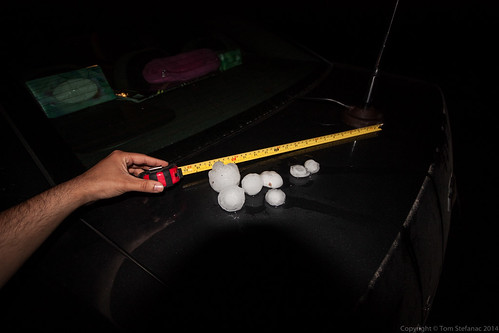
There was a slow moving supercell heading our way and I figured it would be cool to get some video of giant hailstones falling.
We found a perfect hideout, the tornado risk was minimal since the storms were becoming elevated and the hail numbers were going up.
Lightning illuminated the horizon as the storm drew near.
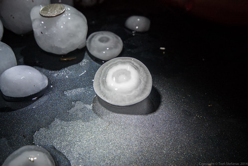
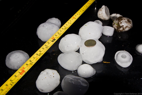
There are two types of hailstones, spikey hail stones and ringed smooth stones. The spike covered ones tend to be soft, but these ones which are far less translucent with many rings are very hard.
If you see them fall, they will often bounce up to three feet into the air after hitting the ground.
These are types of stones that do plenty of damage in just seconds and the type as a storm chase you avoid driving through at all cost!
A good hail core can quickly end your chase day and hurt your pocket book!
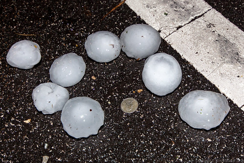
And that was how the day ended!
We'll actually, I took off the lens hood for my Sigma 10-20mm and I never found it!
I guess in the commotion to find the hail stones before they all melted I put it on the truck and totally forgot it there!
To this day, I'm sure it is still in a field at the side of the road somewhere in pieces after being pounded by many hailstorms.
The new lens hood cost me a cool $60. It's not the end of the world but I wont make that mistake twice!
