Posts Tagged: iPad

iPad Air 2
Before I write one word praising Apple or the iPad let me be very clear, I’m not an Apple fanboy. I prefer the Android ecosystem and the flexibility and openness of their devices which include an easy to access and manipulate file system. However there are some things that just work better in combination.
In this case the iPad Air 2 is the ideal platform for the latest version of RadarScope which runs smoothly and virtually flawlessly. The iPad also provides a very stable portable / mobile hotspot for other devices to connect to and the added or increased precessing power ensures that there are no hiccups. So between the hardware and software everything runs very smoothly.
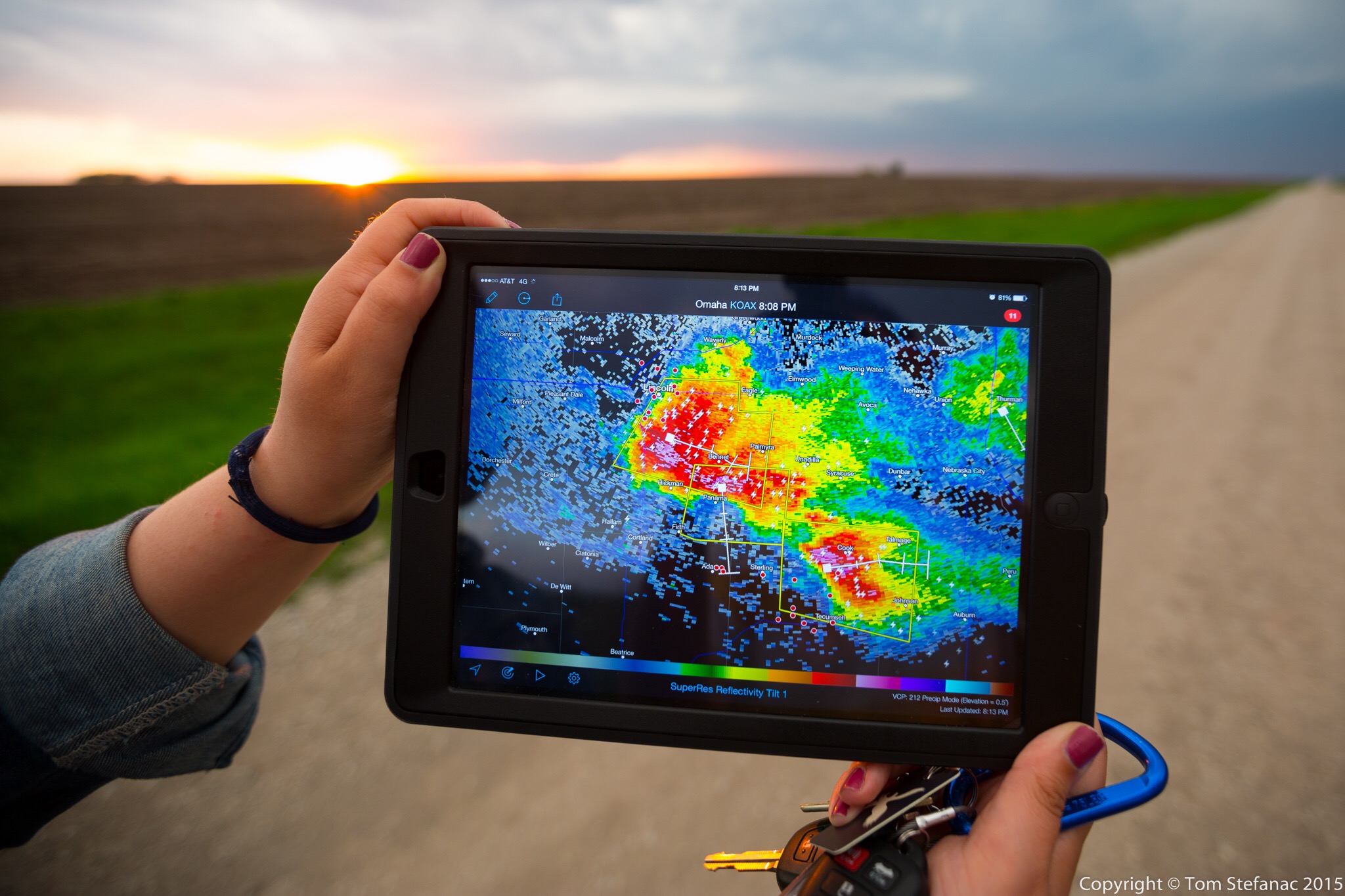
Jen holds the iPad Air 2 in a field showing the radar image of an encroaching supercell thunderstorm which is visible in the background
The reason why I chose the iPad instead of a larger Android tablet is two fold. Firstly, it was simply the only tablet on the market which offered both GSM and CDMA service, so in theory it can run on standard 3G/4G LTE networks but it can also run on Verizon and Sprints weird GSM/CDMA hybrid technology. Secondly, I already have a bunch of Android tablets and wanted something different which would give me a pure integration for RadarScope. Hence, the iPad Air2 was the perfect device to allow me to accomplish both. Using it as a hotspot also allowed me to mitigate the need for an expensive portable hotspot. I find the more devices you need to link together, the more problems you’ll have and the more likely it is that something will go wrong.
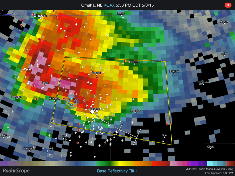
RadarScope showing a large supercell near Hickman NE using Level 3 data
Here’s a small GIF loop taken from the iPad using radar scape showing standard level 3 data from the KOAX radar in Omaha, Nebraska. We’re the blue circle which is derive from the GPS chipset that’s built into the cellular modem in the iPad.

RadarScope showing a chain of storms rolling across central Kansas using Level 2 data.
Here’s another shot showing the iPad in action as we drove through east-central Kansas. You can see that the iPad is in “hotspot” mode sharing the connection with my Dell Tablet which had GREarth running. You’ll also note that the radar data is very fine. RadarScope calls this data “super resolution” but it’s really just the 0.5 degree Level 2 radar data. The beauty however is that the WDT server strips the rest of the layers (0.8 through 19) out and you just have the lowest available level which is really only what we care about when chasing and looking at reflectivity data. By sending out only the needed layer the file is substantially smaller than it would normally be. For example if I attempted to view this same radar data on my Dell Venue 8 using GR2AE one frame of radar data would contain all 19 tilts and be approximately 3mb in size. It’s not a big deal when your in an LTE zone but once a hundred chasers show up and start straining what limited cellular framework there is even LTE data will slow down. Now just imagine trying to use GR2AE when you only have 1 bar of 3G data. So for me it’s simply a more efficient way of looking at the same data.
There are of course trade offs, GR2AE is an incredibly powerful piece of software sporting NROT, MEHS, and other specific algorithms which require all tilts and are extremely accurate and very useful. It can do circles around RadarScope but the reality is when your chasing, you just need basic radar data, all the fancy stuff is for the analysis after the chase or best served as tools that forecasters need when issuing warnings in real-time.
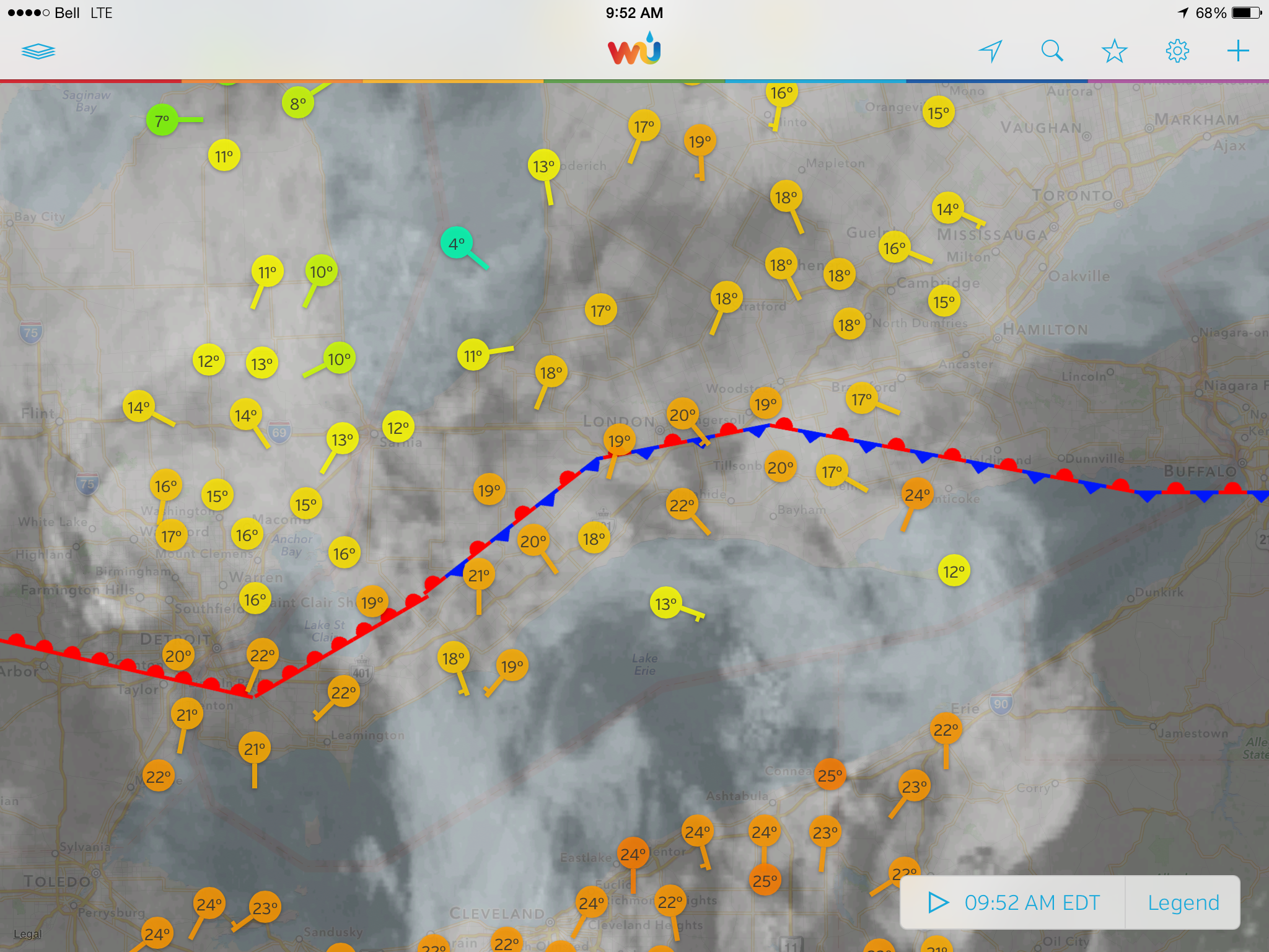
WunderMap App showing surface observations, a stationary front and visible satellite data over Southwestern Ontario
The iPad is also a good tool when used with iPad specific applications such as WunderMap. To explain it in a nutshell, if you know what GREarth is, then WunderMap is an extremely watered down version of that. The one thing the WunderMap App boasts which few other programs can offer is data from personal weather stations and some of this data is real-time updating ever 2 seconds. My own weather station updates every 5 seconds and is used in the WunderMap app. Obviously you need to take any data from these stations with a grain of salt since the quality control and placement can be questionable but it still provides a huge volume of actual observations far greater than you could ever get if you were only use airports, METAR stations and mesonets. So this iPad specific app can be very useful for quick nowcasts or simple situational awareness.