Tornado Alley Blog
May 25th 2017 – Vaughan, Ontario
We’re safely back and the chase is over! What a year, there was plenty of down time but when the storms came in waves, they certainly produced and we had a very successful trip with numerous tornadoes, and beautiful storm structure!


.jpg")


April 30th 2017 – Kansas City, Kansas
What a night. What started with a cold early morning commute, ended with us spinning in circles after chasing a weak line of storms on the IL/MO border. The storms were actually linear in nature but developing in a weak energy environment with favorable low level shear for vorticity. One of the storms produced a brief tornado as we approached from the west, but we were unable get into position in time for it to be visible however several storm reports confirmed it.
Our next target is Woodward Oklahoma for a possible chase Tuesday afternoon near the Panhandle.
April 21st 2017 – Vaughan, Ontario
Well, it’s that time of year again and preparations are underway for this years tornado alley excursion. This trip unlike others which were solo runs with only my fiancée and I will actually include three other chasers. Two fellow chasers from Southern Ontario and one from New Zealand. In addition our trip will run from April 28th to approximately May 20th and will hopefully provide us with an opportunity to explore the beautiful landscapes of the American west and the absolutely stunning skies above.
While still early, the prognosis from the ECMWF weekly ensembles suggest a quick start, followed by intermittent storms that will give way to a major pacific long-wave towards the middle of May. Current climate trends indicate we will see more of a late May type pattern as opposed to a traditional early may pattern.
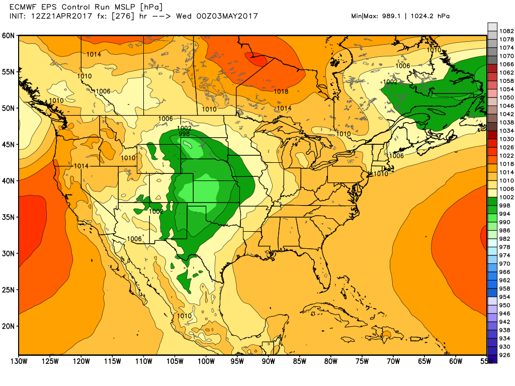
ECMWF MSLP Control Valid 03/05
Unfortunately the smaller mesoscale features which often arise such as front range convection which exists in areas such as DVCZ and near the Palmer Divide are not resolved in the longer range models. So while there is an apparent lull with the larger synoptic meteorology, we do expect there will be storms on apparent off days. Further into the future, the day 15 data which is the end of the observable run suggest a large pacific trough will likely make its way into the plains around May 9th or 10th and possibly trigger a couple high-risk storm days.

ECMWF Weekly – 15D Control 500 hPa
With that said, the forecast at this point will likely change a great deal so be sure to keep checking this blog for updates. I’ll do my best to post daily, nightly and even some rel-time reports once the trip begins.