May 8th 2014 – Forecast Outlook
It’s that time of year when the chase trip begins to come into model range. Usually, I like to base my trip on statistics and the last 10 – 15 years have been pretty consistent with the 17th through 30th producing a plethora of severe weather and the week of the 20th through 25th just going bonkers.
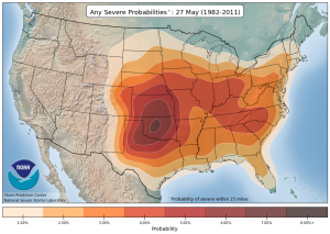
The climate data for severe weather of any sort peaks during May with the most reports for all sorts of weather coming in between the 10th and 30th and the bulk of the severe weather is concentrated in the southern plains specifically affecting central Oklahoma.
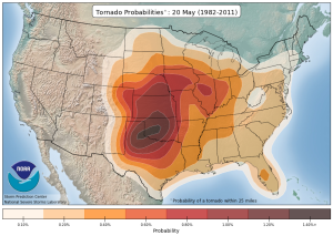
Similarly, violent tornadoes are statistically prevalent through late April and all of May with the peak occurring between the 10th of May and 31st. This map, which looks at the latter half of the month shows that the peak areas are again the Texas Panhandle stretching back into central Oklahoma.
In all my years of chasing this absolutely holds true with late May never failing to producing at least three of four violent tornado outbreaks before June.
ECMWF Weekly Ensembles
The problem with using statistics is that they change over time and there is nothing concrete that says just because this has happened 100 times in the past, it’ll happen again this year. Sure, statistically the odds are highly in favour of that type of an outcome but there is never a guarantee.
So I’m always eager to see what the long range models hint at when the storm chase vacation period comes into their reach.
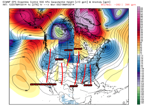
This year, the ECMWF operational which is in good agreement with many of it’s ensemble partners is suggest a relatively active pattern from the 18th onward which looks to reset towards the end of the forecast period (May 22nd) and re-load for another going around on the 23rd or 24th.
It’s always hard to say exactly what that troughing means, all I can say is that the pattern has a number of shortwave and long wave troughs which appear to be associated with deepening and eventually maturing low pressure systems.
How these troughs play out and what type of weather they generate is always a bit of a mystery until it actually happens or at least is within range of the short range models.
The key for me here really is that I’m looking for things I don’t want to see, specifically ridges of high pressure which cap the atmosphere, block the jet stream and provide plenty of boring blue sky. No matter how you slice a ridge, the end result is pretty much the same, so a lack of ridging in essence is far better to see than tons of toughing alone.
Right now, the forecast is very optimistic and it’s look like a very active chase is on tap! I’ll be sure to keep an eye on things as the 15th of May draws closer!


