Posts Tagged: hail
May 3rd 2015
On May 24, 2015
- 2015 Storm Chases
Today was the first real chase day that showed some potential for severe storms. A thermal trof was swinging in from the west and coupling itself with a cold front descending from North Dakota into Eastern Nebraska. The best lapse rates were right on the nose of warm air where there was a southeasterly wind field. The biggest problem at the time was a lack of good 500mb support but otherwise bulk shear numbers were set to rise as the day progressed.
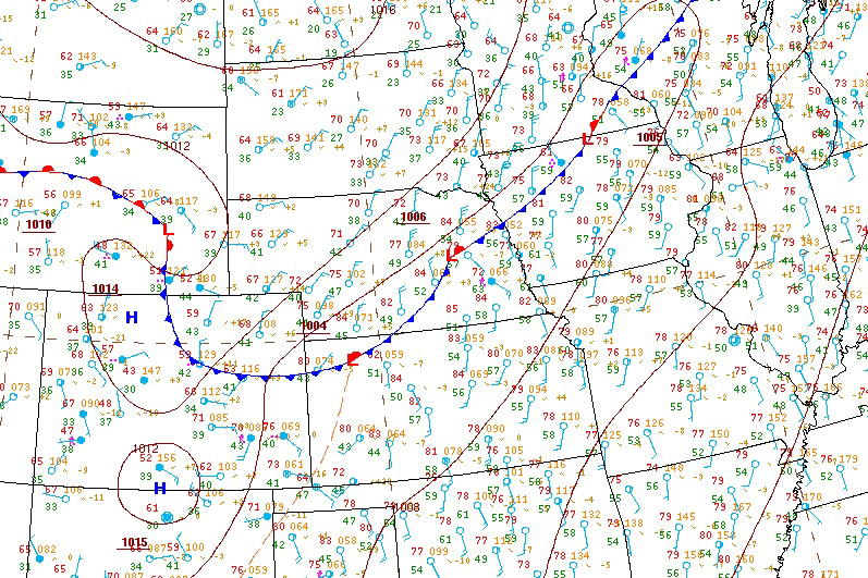
HPC surface analysis 21Z May 3rd 2015

We started by making our way west. After pulling off the interstate near Wood River NE, the road looped around this freshly plowed field and I saw that it was kicking up dust devils. We were just entering the area where the lapse rates were starting to really get steep just along the thermal trof. In fact the winds were actually pretty gusty right in this area and there was some good veering in the low levels.
It was almost like this area where dust devils were being kicked off one after another was sending me a signal.
Needless to say, I love dust devils and had to stop to grab some photos. It's so cool to see them one after another.

I tried to get a shot showing a little more depth and height to the dust devil but it was not easy with the poor contrast between the sky and soil making the vortex visible.

We stopped for gas in Duncan, NE along route 30. I saw that this area had some good cu growth on the visible satellite and it was sitting a long a triple point boundary.
Within about 40 minutes of stopping one of the towers had gone from just that and turned into a CB.

I headed a few miles west out of town and stopped in an area of good clearing to watch the storm develop and grow. It was still very early in the day but it sure looked like a good storm.

I stayed with this particular cell and it grew and morphed with other clouds in the area. It began to exhibit some problems though, namely that the lack of 500mb support was allowing rain to fall through the developing updraft.

There another storm on radar about 50 miles to our south near Lincoln Nebraska that went up quickly and began to exhibit a strong signature on radar.
It look like it was a good storm because it was sitting in a strong area of southerly inflow and secondly it developed along and rode an old outflow boundary from an earlier MCS that rolled through around 10AM CDT.
Jen made the cell to go south to this storm and we did. Jen took this photo as we blasted along the interstate and were just about 30 miles from the storm.

There were some spotters on a local skywarn net giving reports. The storm at this point in time had a pretty nasty core on radar but not much else in the way of structure, lowerings or rotation. The reports that we were hearing indicated golf ball sized hail was falling and getting pretty deep in some places.

On the way to the storm we briefly passed through and stopped in the town of Hickman. The area had suffered some pretty substantial damage from hail shredding the trees and there were golf ball sized stones all over the place.

A little farther down the road east of Hickman we started to run into some of the hail drifts that were being reported on the skywarn net. The temperature also dropped from 90F to a cool 50F thanks to all the ice on the ground.

Here's a bit more of a zoomed in shot showing the amount of hail covering the road.

I snapped this shot of my chase vehicle. You can see way off in the distance the first cell we were chasing.

This was the storms flanking line. Despite looking rather unimpressive the dry air and the steep lapse rates were more than enough to produce all the hail.

It's not too often you see a rainbow that results from hail stones falling but that's exactly what this was. You'll also notice white dots in the field to the right of the frame, those are golf ball sized hail stones.

You can see how the storm had a supercell look on radar despite not having that type of a look from the ground. The purple is where those big hailstones were lurking.

Again, these big golf ball sized hail stones were just laying there.

I decided I was going to take a few close passes along the storms core. The storm was moving slowly, gently drifting towards the southeast and the road network was favourable. If things began to get a little hairy I could also go in the opposite direction and avoid any potential vehicle damage. It was apparent that the hail was really doing some tree shredding.

This was the first close pass I did. You can really see how green it was once you got up under it.

Towards the center left you can see into the storms green core. This area was becoming a vaulted region which meant it was mainly rain free but really big hail was potentially present.


I tried to make a couple passes under the storm and get to the south side but there were hail stones ranging from dollar to golf ball in size getting spit out regularly. In this video grab you can see a few bouncing on the road towards my car.

Eventually I had to sort of go around the storm. I eventually wound up in an area of both inbound and outbound winds. It was really unusual since the wind would randomly blow in different directions. As I started to make my way back towards the storm this little eddy / gustnado spun up and crossed the road.

To my surprise it was loaded with all sort of debris ranging from mud and small stones to twigs and wood chips. It was actually pretty violent and turned the car a wonderful shade of brown!

After our encounter with the gustnado / outflow eddy we stopped to get a better view of whatever the lowering was we had seen before. By the time I got out of the car it was gone but there was clearly a wall cloud trying to form, although a high based one.

You can see our location at time relative to the storm and what might be the edge of the forward flank outflow.

Here's a zoomed in shot of the wall cloud. The storm was now moving into much better bulk shear and you can see how this structure is looking much smoother.

Unfortunately the storm was still pretty high based and older convection to the west was now finally starting to organize!

The new supercell to the west had a bell like look near the setting sun. That's always a good sign since it means a pretty storm is brewing!

I got Jen to show me the iPad with the storm in the background. I figured it was cool to see everything in one shot!

We are the red dot near Sterling.

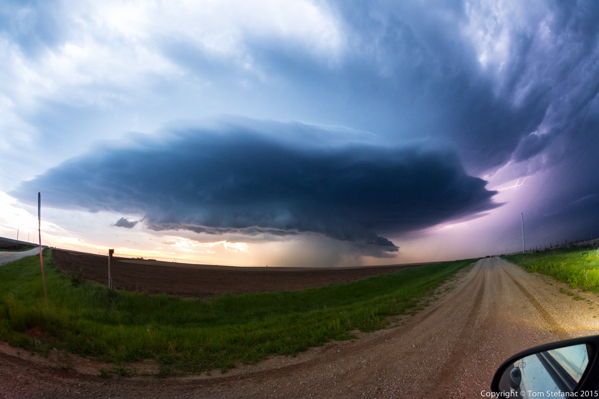
I eventually gave up on the storm I had been with most of the day since it remained elevated and had no solid lowering. We headed west and this was the second approaching supercell which had some beautiful structure!

This was a reported funnel cloud which prompted a tornado warning. The hill creates the optical illusion that it's on the ground but spotters on the other side confirmed it was just a funnel cloud.

Even without a tornado I love to just see beautiful storm structure!

We were right in the edge of the tornado warning and fortunately the storm was low enough in precipitation that we had a good clean view of all the structure.

This was a tough shot! There was still too much daylight for longer exposure lightning shots so I had to use a 1 second rapid-fire setting to catch this.

I dropped a little south of the storm to avoid getting bonked by the three inch sized hailstones this storm was spitting out!

As dusk turned into night I moved west and setup for lightning shots.


This storm kept going for a very long time but failed to ever produce a confirmed tornado despite the persistent and visible wall cloud to the center-right of the screen.